
UA Researchers on Winning Team in Lunar Exploration Competition
By Emily Dieckman
By Emily Dieckman, UA College of Engineering - February 9, 2018
Pink Floyd aside, there isn't actually a dark side of the moon — just a side you can't see from Earth. That is, unless you're a researcher like those at the University of Arizona and partnering institutions, who are setting out to investigate meteoritic impact on the far side of the moon.
The Lunar Meteoroid Impacts Observer, or LUMIO, project is headed by Francesco Topputo, an assistant professor in aerospace systems at Polytechnic University of Milan in Italy.
Roberto Furfaro, associate professor in the Department of Systems and Industrial Engineering and Department of Aerospace and Mechanical Engineering, and Vishnu Reddy, assistant professor at the Lunar and Planetary Laboratory, make up the UA team of the LUMIO mission study.
The project aims to use an advanced camera to monitor meteorites striking the moon. Combined with existing Earth-based monitoring, these observations could create a more complete picture of what happens when meteorites hit the lunar surface, and of the spatial distribution of these impacts. Understanding where meteorites that hit the moon come from — and when they hit — helps us understand the debris environment in near-Earth space.
"LUMIO will enable us to answer some key questions about small object population around the Earth-moon system," said Reddy, who came up with the science justification for the mission.
Also involved are Delft University of Technology in the Netherlands, École polytechnique fédérale de Lausanne in Switzerland, Italian aerospace and defense company Leonardo, Science & Technology Corp. in Norway, and the European Space Agency's European Space Research and Technology Center in the Netherlands.
Calling All CubeSats
SysNova, a European Space Agency initiative that uses technology challenges to attract the best proposals from European companies, universities and research centers, first asked for proposals for its Lunar CubeSats for Exploration competition in late 2016, and about 60 teams answered the call. In spring 2017, four teams were selected as finalists, receiving grants of about $100,000 and six months for initial studies. LUMIO was selected as the winner in December.
CubeSats are miniature satellites made up of 10-by-10-by-10-centimeter cubic units called U's. Originally used in university settings so students could design and run their own missions, CubeSats' low cost, low weight and increasingly powerful processing capabilities have been receiving more attention from national space agencies in recent years. Roger Walker, a project manager for educational satellite projects at the European Space Agency, compared the standard satellites of today to PCs and CubeSats to smartphones.
"Now agencies are exploring the feasibility of sending these cubes out not just around Earth, but to explore other areas," Furfaro said.
Kevin Jacquinot, who earned his master's degree in aerospace systems at the UA in 2017, designed a CubeSat for an independent study course working for Furfaro. After graduation, he did some systems engineering for LUMIO.
"Because of LUMIO, I was put in contact with the European Space Agency, and I'm actually waiting for an answer from them about working on another lunar exploration project," he said. "I would love to work on a project like this again."
As director of the Space Situational Awareness Arizona initiative, Furfaro works with other UA faculty to understand and characterize the behavior of objects in space.
One aim of the LUMIO mission is to increase lunar situational awareness, or what might impact the moon. This could be particularly important for the U.S., in light of a directive President Donald Trump signed in December formally instructing NASA to send more astronauts to the moon.
"If we're going to go back to the moon, like the president announced, we have to also have a better understanding of the moon environment," Furfaro said.
As winners of the challenge, the LUMIO team will conduct a concurrent engineering study with ESA in the coming months.
"Then, if everything goes well, there'll be a good chance we're going to fly it," Furfaro said.
Mission to the Moon
LUMIO would be about 12U (2Ux2Ux3U) and weigh about 50 pounds (roughly one-hundredth the weight of NASA's New Frontier spacecraft). In phase one of its mission, it would be transported to the moon on another vehicle, then begin its lunar, or selenocentric, orbit.
In phase two, the transfer phase, LUMIO would travel beyond the moon to L2, a gravitational parking spot that astrodynamicists refer to as a "Lagrange point" (named for an 8th-century mathematician), which will allow LUMIO to maintain its relative position to the moon as it orbits the earth.
In phase three, the operative phase, LUMIO would begin orbiting L2 in approximately 29-day rotations — the same length as the lunar cycle itself.
In the two weeks surrounding the far side's new moon — a full moon from Earth's perspective — the moon will be dark enough for LUMIO to observe and record meteoric impacts. The moon will be too bright to observe during the other two weeks, so scientists will use the time to recalibrate LUMIO's navigation system and keep it on the right trajectory.
LUMIO would orbit L2 for about a year, followed by disposal, which may involve crashing LUMIO onto the lunar surface. Another spacecraft with the right instrumentation could gain valuable information about the moon's subsurface by observing the debris and materials stirred up by LUMIO upon impact.

Rapid Detection and Recovery: The Science of Hunting Meteorites
By Emily Walla, NASA
By Emily Walla, NASA Space Grant Intern, University Communications - February 6, 2018
At 8:10 p.m. on Jan. 16, hundreds of people in Michigan reported the bright glow of a meteor streaking through the sky, rattling windows as it broke the sound barrier. The meteor then broke apart in the Earth's atmosphere, and its pieces rained quietly to the ground.
Using predictions by the Rapid Detection and Recovery of Meteorites, or RADARMET, project, scientists and meteorite hunters were able to recover more than half a dozen fragments of the rock within two days of the fall.
RADARMET is led by Vishnu Reddy, assistant professor in the University of Arizona's Lunar and Planetary Laboratory. He procured funding from NASA to operate RADARMET, which uses National Weather Service Doppler radar data and computer models to locate meteorites within hours of their fall.
"Historically, people would see a meteor in the sky and they would say, 'I saw it go that way behind the tree,'" Reddy said. "Even if someone takes a picture of the meteor, using the image to trace a trajectory for the meteorite is difficult and can be quite time-consuming."
Upper-atmosphere winds make extrapolation challenging, Reddy said. For a meteor to survive the trip through the atmosphere and fall onto the ground as a meteorite, it has to slow from its cosmic velocity. The friction from the atmosphere makes the meteor glow visibly between 30 and 65 miles above ground.
"Typically, meteorite-dropping meteors need to slow down to around 6,700 mph, the speed when they no longer glow brightly while descending into the atmosphere," Reddy said.
Falling at Terminal Velocity
The meteor then enters a period known as "dark flight," during which it falls at terminal velocity. During this dark flight, winds in the upper atmosphere can buffet the meteorite miles away from where its glowing bright flight ends.
Marc Fries, Reddy's co-investigator for RADARMET and a scientist at NASA's Johnson Space Center, developed a method that can predict how a meteorite would travel during its dark flight. He also has developed software tools to calculate where meteorites land under the influence of winds, and to estimate the total mass that reaches the ground.
Tanner Campbell, a UA graduate student in aerospace and mechanical engineering, adapted Fries' dark flight model into a computer program that quickly and accurately determines where a meteorite will fall.
"We can accomplish this because the kinetics of an object in near freefall are known quite well," Campbell said. "Since these meteorites are typically fairly small, we can make some assumptions about how they travel through the atmosphere. We can then take whatever data can be gathered on the meteorite while it is glowing in the sky, and measured atmospheric data from near the event, and use it to predict the path to the ground."
Atmospheric data include wind speeds and information collected by weather radar stations, which detect anything falling through the air, whether it is rain, birds, airplanes or meteorites. Although the radar cannot distinguish between a sparrow and a space rock, the RADARMET team has a method to do just that.
"The first trigger is eyewitness reports from the public," Reddy said.
Using an online tool on the American Meteor Society website, members of the public can log their location, which direction they were facing and how long the meteor was visible in the sky. When an event has corroborating videos and other evidence such as sonic booms, Reddy and his co-investigators download radar data from the nearest weather station and power up the dark flight model.
Accuracy of Location Is Vital
Within hours of the event, the RADARMET team can locate the exact area where meteorite fragments have fallen. The information is quickly shared with the public, including scientists and meteorite hunters. RADARMET's method is so accurate that hunters have been able to travel to a location, park their cars and find meteorites within that parking lot.
When hunting meteorites, time is of the essence. The sooner a sample is found, the more scientists can learn from it.
"The longer a meteorite sits on the Earth, the less scientifically useful it becomes, because the weathering process degrades the minerals and destroys it," Reddy said.
Rain can dissolve and wash away minerals, microbes can contaminate any evidence of the building blocks of life, and oxygen can rust the iron in the meteorite within a day.
Although recovering pieces of the Michigan meteorite took slightly more than a day, some samples were found in nearly pristine condition. One piece was found in ice, protected from exposure to liquid water. Pristine samples such as this one enable scientists to study materials that are easily destroyed or of astrobiological significance.
Reddy and students in the UA Department of Planetary Sciences plan to be involved in the study of the meteorite.
"While we're not out there hunting the meteorites, we're doing the science," Reddy said.
Steep Slopes on Mars Reveal Structure of Buried Ice
By University
By University Communications - January 12, 2018
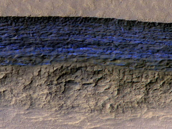
Researchers using the University of Arizona-led HiRISE camera aboard NASA's Mars Reconnaissance Orbiter, or MRO, have found eight sites where thick deposits of ice beneath Mars' surface are exposed in faces of eroding slopes.
These eight scarps, with slopes as steep as 55 degrees, reveal new information about the internal layered structure of previously detected underground ice sheets in Mars' middle latitudes.
The ice was likely deposited as snow long ago. The deposits are exposed in cross section as relatively pure water ice, capped by a layer 1 to 2 yards (or meters) thick of ice-cemented rock and dust. They hold clues about Mars' climate history. They also may make frozen water more accessible than previously thought to future robotic or human exploration missions.
Researchers who located and studied the scarp sites with the HiRISE, or High Resolution Imaging Science Experiment, camera on MRO reported the findings on Jan. 11 in the journal Science. The sites are in both the northern and southern hemispheres of Mars, at latitudes from about 55 to 58 degrees, equivalent on Earth to Scotland or the tip of South America.
"There is shallow ground ice under roughly a third of the Martian surface, which records the recent history of Mars," said the study's lead author, Colin Dundas, of the U.S. Geological Survey's Astrogeology Science Center in Flagstaff, Arizona. "What we've seen here are cross sections through the ice that give us a 3-D view with more detail than ever before."
Windows Into Underground Ice
The scarps directly expose bright glimpses into vast underground ice previously detected with spectrometers on NASA's Mars Odyssey orbiter, with ground-penetrating radar instruments on MRO and on the European Space Agency's Mars Express orbiter, and with observations of fresh impact craters that uncover subsurface ice. NASA sent the Phoenix lander to Mars in response to the Odyssey findings; in 2008, the Phoenix mission confirmed and analyzed the buried water ice at 68 degrees north latitude, about one-third of the way to the pole from the northernmost of the eight scarp sites.
"The discovery gives us surprising windows where we can see right into these thick underground sheets of ice," said Shane Byrne of the UA Lunar and Planetary Laboratory, a co-author on the new report. "It's like having one of those ant farms where you can see through the glass on the side to learn about what's usually hidden beneath the ground."
Scientists have not determined how these particular scarps initially form. However, once the buried ice becomes exposed to Mars' atmosphere, a scarp likely grows wider and taller as it "retreats," due to sublimation of the ice directly from solid form into water vapor. At some of them, the exposed deposit of water ice is more than 100 yards, or meters, thick. Examination of some of the scarps with MRO's Compact Reconnaissance Imaging Spectrometer for Mars, or CRISM, confirmed that the bright material is frozen water. A check of the surface temperature using Odyssey's Thermal Emission Imaging System, or THEMIS, camera helped researchers determine they're not seeing just thin frost covering the ground.
Researchers previously used MRO's Shallow Radar, or SHARAD, to map extensive underground water-ice sheets in middle latitudes of Mars and estimate that the top of the ice is less than about 10 yards beneath the ground surface. How much less? The radar method did not have sufficient resolution to say. The new ice-scarp studies confirm indications from fresh-crater and neutron-spectrometer observations that a layer rich in water ice begins within just 1 or 2 yards of the surface in some areas.
Astronauts' Access to Martian Water
The new study not only suggests that underground water ice lies under a thin covering over wide areas, it also identifies eight sites where ice is directly accessible, at latitudes with less hostile conditions than at Mars' polar ice caps.
"Astronauts could essentially just go there with a bucket and a shovel and get all the water they need," Byrne said.
The exposed ice has scientific value apart from its potential resource value because it preserves evidence about long-term patterns in Mars' climate. The tilt of Mars' axis of rotation varies much more than Earth's, over rhythms of millions of years. Today the two planets' tilts are about the same. When Mars tilts more, climate conditions may favor buildup of middle-latitude ice. Dundas and co-authors say that banding and color variations apparent in some of the scarps suggest layers "possibly deposited with changes in the proportion of ice and dust under varying climate conditions."
This research benefited from coordinated use of multiple instruments on Mars orbiters, plus the longevities at Mars now exceeding 11 years for MRO and 16 years for Odyssey. Orbital observations will continue, but future missions to the surface could seek additional information.
"If you had a mission at one of these sites, sampling the layers going down the scarp, you could get a detailed climate history of Mars," suggested MRO deputy project scientist Leslie Tamppari of NASA's Jet Propulsion Laboratory in Pasadena, California. "It's part of the whole story of what happens to water on Mars over time: Where does it go? When does ice accumulate? When does it recede?"
The UA operates HiRISE, which was built by Ball Aerospace & Technologies Corp. of Boulder, Colorado. The Johns Hopkins University Applied Physics Laboratory, Laurel, Maryland, leads MRO's CRISM investigation. The Italian Space Agency provided MRO's SHARAD instrument; Sapienza University of Rome leads SHARAD operations; and the Planetary Science Institute, based in Tucson, leads U.S. involvement in SHARAD. Arizona State University leads the Odyssey mission's THEMIS investigation. JPL, a division of Caltech in Pasadena, California, manages the MRO and Odyssey projects for the NASA Science Mission Directorate in Washington. Lockheed Martin Space, Denver, built both orbiters and supports their operation.

UA in the Running for a New NASA Mission
By University
By University Communications - December 21, 2017
NASA has chosen a planetary mission involving a team from the University of Arizona as one of two finalists to be the next robotic solar system explorer. The proposed mission, named CAESAR, for Comet Astrobiology Exploration Sample Return, seeks to return a sample from a comet to determine its origin and history.
UA Lunar and Planetary Laboratory professor Dante Lauretta is CAESAR's mission sample scientist, responsible for leading the analysis of the returned comet sample. He also is tasked with advising on all aspects of the mission's design that influence the scientific value and integrity of the sample. Lauretta is currently principal investigator of NASA's OSIRIS-REx asteroid sample return mission, which launched in September 2016 and will return NASA's first asteroid sample to Earth in 2023.
LPL associate professor Tom Zega is a co-investigator on the CAESAR mission and would analyze the comet sample material once it is back on Earth. Zega, currently a collaborator on the OSIRIS-REx mission, will be one of the first scientists to analyze samples from the asteroid Bennu.
"We are excited to bring the UA's leadership in sample science innovation to the challenges posed by the CAESAR mission and its target comet," Lauretta said. "The work done on CAESAR will ensure that the UA continues to stand at the forefront of extraterrestrial sample analysis for the next 20 years."
If selected, CAESAR would be the fourth mission in NASA's $1 billion New Frontiers program, which sends robotic spacecraft to conduct science-intensive planetary investigations. The UA leads the third New Frontiers mission, OSIRIS-REx, currently on its way to the asteroid Bennu to retrieve a sample of its surface for study on Earth.
"This is a wonderful opportunity to apply the experience that the UA has gained from OSIRIS-REx to another frontier in planetary science," said Kimberly Andrews Espy, UA senior vice president for research. "We are delighted to be able to continue the University's tradition of leadership in exceptional NASA missions."
CAESAR's target comet is 67P/Churyumov-Gerasimenko, which previously was explored by the European Space Agency's Rosetta spacecraft. If the mission is ultimately chosen, the CAESAR spacecraft could launch by 2025 and return to Earth in 2038. The mission is led by Steve Squyres of Cornell University and managed by NASA's Goddard Space Flight Center. NASA intends to make the final mission selection in summer 2019. Between now and then, the two finalist missions will receive funding from NASA to further advance the missions' concepts and designs.
The other finalist mission, Dragonfly, is led by LPL alumna Elizabeth Turtle, who earned her Ph.D. in planetary science in 1998 and then continued at LPL as both a postdoctoral fellow and as research faculty before joining the Johns Hopkins University Applied Physics Laboratory in Laurel, Maryland. The Dragonfly spacecraft is a dronelike rotorcraft that would explore the prebiotic chemistry and habitability of dozens of sites on Saturn's moon Titan, an ocean world in our solar system.

UA Students Participate in First Global Planetary Defense Exercise
By Emily Walla, NASA
By Emily Walla, NASA Space Grant Intern, University Communications - December 4, 2017
University of Arizona students recently took part in a NASA-led international exercise that used a real asteroid flyby to test global planetary defense capabilities. The project was designed to exercise how astronomers' efficiency in determining the orbit, rotation, shape, size and composition of an asteroid that could potentially impact the Earth. The campaign was led by Vishnu Reddy, assistant professor in the UA's Lunar and Planetary Laboratory.
The exercise's target was the asteroid 2012 TC4. The small asteroid — only 50 feet long and 25 feet wide — was on course to closely approach Earth. On Oct. 12, TC4 safely passed the planet, coming within 27,200 miles of the surface (that's about 5,000 miles above the orbit of geostationary satellites). In the months before the flyby, astronomers from the U.S., Canada, Colombia, Germany, Israel, Italy, Japan, the Netherlands, Russia and South Africa tracked TC4 using ground- and space-based telescopes from around the world.
Planning for the so-called TC4 Observation Campaign started in April, under the sponsorship of NASA's Planetary Defense Coordination Office. The exercise commenced in earnest in late July, when the European Southern Observatory's Very Large Telescope spotted the asteroid. The finale was a close approach to Earth in mid-October.
Graduate and undergraduate students at the UA were given the opportunity to participate in the project as part of a class Reddy taught with Walt Harris, professor in the Department of Planetary Sciences.
Using observations collected during the campaign, scientists at NASA's Jet Propulsion Laboratory, or JPL, were able to precisely calculate TC4's orbit, predict its flyby distance on Oct. 12 and rule out the possibility of a collision between Earth and the asteroid.
RAPTORS Network Put to Use
A network of telescopes, including the student-built Rapid Astronomical Pointing Telescopes for Optical Reflectance Spectroscopy, or RAPTORS, housed on the UA campus, was used to study how fast TC4 rotates. Given that TC4 is small, astronomers expected it to be rotating fast. They were surprised to find that the object was not only spinning once every 12 minutes, it also was tumbling.
A team of UA undergraduate students from Reddy's class observed the asteroid using RAPTORS.
"Observing using RAPTORS went beautifully," said Collin Lewin, one of Reddy's undergraduate students. "The opportunity to operate a telescope like RAPTORS is rare for undergraduates, so this was a valuable experience for many students."
Finding out what TC4 is made of turned out to be more challenging. Is the asteroid rich in carbon, or does it consist of bright rocky materials? Infrared observations made with NASA's Infrared Telescope Facility, or IRTF, at the Mauna Kea Observatory in Hawaii would allow scientists to identify the asteroid's composition. On a trip funded by the Lunar and Planetary Laboratory's external advisory board, graduate students from the UA traveled to Hawaii to perform the necessary observations.
The work done by Reddy's students would allow NASA to know exactly what materials comprised which parts of the asteroid. Although they were able to collect some data before the asteroid's close approach, adverse weather conditions and technical difficulties prevented Reddy's graduate students at IRTF from taking observations during TC4's flyby on Oct. 12.
"Something always goes wrong. You have to learn how to deal with it," said Cassandra Lejoly, a doctoral student in Reddy's class.
Others in Reddy's class, such as doctoral student Ben Sharkey, noted that the experience was useful for students who were unsure of the direction in which they wished to take their careers.
"This experience gave them an idea of what observing takes. It might help those students decide if they want to have to deal with the difficulties that come with observing," Sharkey said.
"Whether or not our graduate students are going to use telescopes in their professional careers, they are going to work with people who do," said Timothy Swindle, director of the Lunar and Planetary Laboratory. "One of the important things in a graduate student's education is learning about the tools that you use, and the tools used by the people you work with. This was one opportunity for them to see how a telescope really works."
Rare Opportunity for Students
Most observing can be done remotely, as the telescopes can send data to computers far from the observatories.
"Learning how to use a telescope as complicated as IRTF is something that few people get to do in person," said Teddy Kareta, a first-year doctoral student at LPL. Witnessing the inner workings of the telescope granted students such as Kareta a deeper understanding and respect for the instruments and the people who operate and repair them.
"No one expected the observing trip to be quite as tumultuous as it was, but the students learned that when trying to do great things, they will face setbacks along the way," Swindle said.
Although the setbacks at IRTF threw a small wrench in the observation campaign, scientists at JPL were nevertheless able to determine what materials were present at the surface of the asteroid. Radar scattering properties of TC4 are consistent with a bright, rocky surface, similar to a particular class of meteorites that reflect 50 percent of light that hits them.
In addition to the observation campaign, NASA used this exercise to test communications between the many observers and also to test internal U.S. government messaging and communications up through the executive branch and across government agencies. Such would be necessary during an actual impact emergency.
"We demonstrated that we could organize a large, worldwide observing campaign on a short timeline, and communicate results efficiently," Reddy said.

Recurring Martian Streaks: Flowing Sand, Not Water?
Jet Propulsion
Jet Propulsion Laboratory/Caltech and University Communications - Nov. 21, 2017
Dark features on Mars previously considered evidence for subsurface flowing of water are interpreted by new research as granular flows, where grains of sand and dust slip downhill to make dark streaks, rather than the ground being darkened by seeping water.
Continuing examination of these still-perplexing seasonal dark streaks with the UA-led High Resolution Imaging Science Experiment, or HiRISE, camera on NASA's Mars Reconnaissance Orbiter, or MRO, shows they exist only on slopes steep enough for dry grains to descend the way they do on faces of active dunes.
The findings published in Nature Geoscience argue against the presence of enough liquid water for microbial life to thrive at these sites. However, exactly how these numerous flows begin and gradually grow has not yet been explained. Authors of the report propose possibilities that include the involvement of small amounts of water, indicated by detection of hydrated salts observed at some of the flow sites.
These features have evoked fascination and controversy since their 2011 discovery, as possible markers for unexpected liquid water or brine on an otherwise dry planet. They are dark streaks that extend gradually downhill in warm seasons, then fade away in winter and reappear the next year. On Earth, only seeping water is known to have these behaviors, but how they form in the dry Martian environment remains unclear.
Many thousands of these Martian features, collectively called "recurring slope lineae," or RSL, have been identified in more than 50 rocky-slope areas, from the equator to about halfway to the poles.
'Mars Today Is Very Dry'
"We've thought of RSL as possible liquid water flows, but the slopes are more like what we expect for dry sand," said Colin Dundas of the U.S. Geological Survey's Astrogeology Science Center in Flagstaff, Arizona. "This new understanding of RSL supports other evidence that shows that Mars today is very dry."
Dundas is lead author of the report, which is based on observations with the HiRISE camera on MRO. The data include 3-D models of slope steepness using pairs of images for stereo information. Dundas and co-authors examined 151 RSL features at 10 sites.
The RSL are almost all restricted to slopes steeper than 27 degrees. Each flow ends on a slope that matches the dynamic "angle of repose" seen in the slumping dry sand of dunes on Mars and Earth. A flow due to liquid water should readily extend to less steep slopes.
"The RSL don't flow onto shallower slopes, and the lengths of these are so closely correlated with the dynamic angle of repose, it can't be a coincidence," said HiRISE principal investigator Alfred McEwen at the UA's Lunar and Planetary Laboratory, a co-author of the new report.
The seasonal dark streaks have been thought of as possible evidence for biologically significant liquid water — sufficient water for microbial life — although explaining how so much liquid water could exist on the surface in Mars' modern environment would be challenging. A granular-flow explanation for RSL fits with the earlier understanding that the surface of modern Mars, exposed to a cold, thin atmosphere, lacks flowing water. A 2016 report also cast doubt on possible sources of underground water at RSL sites. Liquid water on today's Mars may be limited to traces of dissolved moisture from the atmosphere and thin films, which are challenging environments for life as we know it.
However, RSL remain puzzling. Traits with uncertain explanations include their gradual growth, their seasonal reappearance, their rapid fading when inactive, and the presence of hydrated salts, which have water molecules bound into their crystal stucture.
RSL Formation a Mystery
The new report describes possible connections between these traits and how RSL form. For example, salts can become hydrated by pulling water vapor from the atmosphere, and this process can form drops of salty water. Seasonal changes in hydration of salt-containing grains might result in some trigger mechanism for RSL grainflows, such as expansion, contraction or release of some water. Darkening and fading might result from changes in hydration. If atmospheric water vapor is a trigger, then a question is why the RSL appear on some slopes but not others.
"RSL probably form by some mechanism that is unique to the environment of Mars," McEwen said, "so they represent an opportunity to learn about how Mars behaves, which is important for future surface exploration."
"Full understanding of RSL is likely to depend upon on-site investigation of these features," said MRO project scientist Rich Zurek of NASA's Jet Propulsion Laboratory in Pasadena, California. "While the new report suggests that RSL are not wet enough to favor microbial life, it is likely that on-site investigation of these sites will still require special procedures to guard against introducing microbes from Earth, at least until they are definitively characterized. In particular, a full explanation of how these enigmatic features darken and fade still eludes us. Remote sensing at different times of day could provide important clues."
Operated by the UA, HiRISE was built by Ball Aerospace & Technologies Corp. of Boulder, Colorado. JPL, a division of Caltech in Pasadena, California, manages the MRO project for the NASA Science Mission Directorate in Washington. Lockheed Martin Space Systems of Denver built the orbiter and supports its operations.
Earth's New Buddy Is Asteroid, Not Space Junk
By Daniel Stolte
By Daniel Stolte, University Communications and Vishnu Reddy,LPL - Oct. 17, 2017
Is it a bird? Is it a plane? Or maybe, as some have speculated, a burned-out rocket booster, trapped in a near-Earth orbit around the sun and only occasionally getting close enough to be studied with even the largest telescopes?
Not at all, as it turns out. Based on previous observations, most astronomers had strongly suspected that object (469219) 2016 HO3 was an ordinary asteroid and not space junk. But it took a team of astronomers led by Vishnu Reddy, assistant professor at the University of Arizona's Lunar and Planetary Laboratory, working with one of the world's largest telescopes, the Large Binocular Telescope, or LBT, on Mount Graham in southeastern Arizona, to learn the true nature of this near-Earth object.
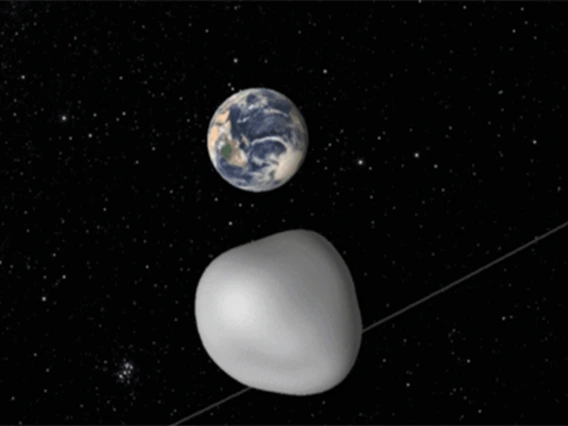
2016 HO3 is a small near-Earth object, or NEO, measuring no more than 100 meters (330 feet) across that, while orbiting the sun, also appears to circle around the Earth as a "quasi-satellite." Only five quasi-satellites have been discovered so far, but 2016 HO3 is the most stable of them. The provenance of this object is unknown. On timescales of a few centuries, 2016 HO3 remains within 38-100 lunar distances from us.
"While HO3 is close to the Earth, its small size — possibly not larger than 100 feet — makes it challenging target to study," Reddy said. "Our observations show that HO3 rotates once every 28 minutes and is made of materials similar to asteroids."
Soon after its discovery in 2016, astronomers were not sure where this object came from, but in a recent presentation at the annual Division for Planetary Sciences Conference of the American Astronomical Society in Provo, Utah, Reddy and his colleagues showed that Earth's new traveling buddy is an asteroid and not space junk. The new observations confirm that 2016 HO3 is a natural object of similar provenance to other small NEOs that zip by the Earth each month.
"In an effort to constrain its rotation period and surface composition, we observed 2016 HO3 on April 14 and 18 with the Large Binocular Telescope and the Discovery Channel Telescope," Reddy said. "The derived rotation period and the spectrum of emitted light are not uncommon among small NEOs, suggesting that 2016 HO3 is a natural object of similar provenance to other small NEOs."
In their presentation "Ground-based Characterization of Earth Quasi Satellite (469219) 2016 HO3" at the 49th annual Division for Planetary Sciences meeting in Utah, Reddy and his co-authors, Olga Kuhn, Audrey Thirouin, Al Conrad, Renu Malhotra, Juan Sanchez and Christian Veillet, point out that the light reflected off the surface of 2016 HO3 is similar to meteorites we have on Earth.
One way to visualize HO3's orbit is by picturing a hula hoop dancer — the sun in this analogy — twirling two hoops around the hips at the same time, ever so slightly out of sync. While it orbits the sun, the object makes yearly loops around the Earth. As a result, the object appears to orbit the Earth, but it is not gravitationally bound to our planet.
"Of the near-Earth objects we know of, these types of objects would be the easiest to reach, so they could potentially make suitable targets for exploration," said Veillet, director of the LBT Observatory. "With its binocular arrangement of two 8.4-meter mirrors, coupled with a very efficient pair of imagers and spectrographs like MODS, LBT is ideally suited to the characterization of these Earth's companions."
NASA Near-Earth Object Observations Program Grant NNX17AJ19G (PI: Reddy) funded parts of this work.

Earth to OSIRIS-REx Cameras: I'm Ready for My Close-Up
University
University Communications - October 4, 2017
On Sept. 22, OSIRIS-REx soared under the South Pole, coming within 10,600 miles of Earth before using the planet's gravity to slingshot itself onto the path to the asteroid Bennu.
The flyby was the perfect opportunity for the OSIRIS-REx team to calibrate and test the science instruments on the craft — and exercise the team.
"It’s really important that all of the team members know where they fit in the processes and that the lines of communication are well understood," said Heather Enos, deputy principal investigator of the mission led by the University of Arizona.
NavCam 1 — a navigational camera operated by Lockheed Martin — captured OSIRIS-REx's first black-and-white image of Earth, taken at a distance of 69,000 miles. Hurricane Maria and the remnants of Hurricane Jose can be seen in the upper right of the image.
About 37,000 miles farther away, MapCam snapped a series of images of Earth, using five different filters. The mission's image processing team at the UA combined the images to create the color composite of Earth.
MapCam is designed to photograph Bennu, a body that reflects only 4 percent of the sunlight that hits it; it is darker than coal. Earth is much, much brighter than that, so the image had to be taken using extremely short exposure times, causing the appearance of dark "icicles" at the top of the color portrait of Earth.
"MapCam was taking the data as quickly as it can," principal investigator Dante Lauretta said. "There was just some noise left on the detector. We won't have any of those features when we're at Bennu."
As it flew away from Earth, OSIRIS-REx aimed its spectrometers at our home planet. Those instruments performed a unique observation: collecting spectral data over Earth's entire visible surface.
"We’ll be doing some interesting science with it, so stay tuned," Lauretta said.
OSIRIS-REx is scheduled to get up close and personal with the 4.5 billion-year-old asteroid in November 2018. After searching the sky around Bennu for other bodies, assessing the asteroid's risk of impact with Earth, using the spectrometers to analyze its chemistry and collecting a sample from its surface, OSIRIS-REx will return to Earth in 2023.
From the mission, researchers hope to learn more about the origins of life and the solar system.
Asteroid-Comet Is New Type of Object
By ESA/Hubble Space
By ESA/Hubble Space Telescope and Daniel Stolte, University Communications - Sept. 25, 2017
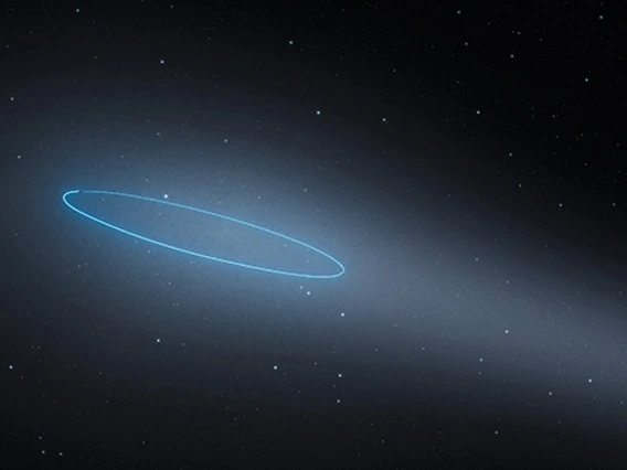
With the help of the NASA/ESA Hubble Space Telescope, astronomers have observed the intriguing characteristics of an unusual type of object in the asteroid belt between Mars and Jupiter: two asteroids orbiting each other and exhibiting cometlike features, including a bright coma and a long tail. This is the first known binary asteroid also classified as a comet. The research is published in the journal Nature.
Asteroid 288P was discovered by the University of Arizona's SPACEWATCH® program in 2006, according to Stephen Larson, a senior staff scientist at the UA's Lunar and Planetary Laboratory and a co-author on the paper. Cometary activity was noticed in Hawaii Pan-Starrs data in 2011 as it approached perihelion — close approach to the sun — and is the first known "main belt comet" as it orbits in the main asteroid belt between Mars and Jupiter.
In September 2016, just before the asteroid 288P made its closest approach to the sun, it was close enough to Earth to allow astronomers a detailed look at it using the NASA/ESA Hubble Space Telescope. Like any object orbiting the sun, 288P travels along an elliptical path, bringing it closer to and farther away from the sun during the course of one orbit.
The images of 288P revealed that it actually was not a single object but two asteroids of almost the same mass and size, orbiting each other at a distance of about 100 kilometers (62 miles). That discovery was in itself an important find; because they orbit each other, the masses of the objects in such systems can be measured.
But the observations also revealed ongoing activity in the binary system. The team of authors of this paper has been working for several years trying to identify the mechanism for the observed activity using the Hubble Space Telescope, Larson said.
"These so-called active asteroids are likely comets that have lost most of their volatile ices and may provide the link between comets and some asteroids," he said. "There are about 20 known active asteroids that result from collisions, volatile gas outgassing and splitting due to rotational spin-up."
"We detected strong indications of the sublimation of water ice due to the increased solar heating — similar to how the tail of a comet is created," explained Jessica Agarwal of the Max Planck Institute for Solar System Research in Germany, the team leader and main author of the research paper. This makes 288P the first known binary asteroid that also is classified as a main-belt comet.
Understanding the origin and evolution of main-belt comets — asteroids orbiting between Mars and Jupiter that show comet-like activity — is a crucial element in our understanding of the formation and evolution of the whole solar system. Among the questions main-belt comets can help to answer is how water came to Earth. Current research indicates that water came to Earth not via comets, as long thought, but via icy asteroids. Since only a few objects of this type are known, 288P presents itself as an extremely important system for future studies.
"The high resolution of the Hubble Space Telescope provides unique data constraining the various processes at work in active asteroids," Larson said. "A few of these have been discovered by the UA Catalina Sky Survey, which also provides 14 years of data on historical activity of these active asteroids."
The various features of 288P — wide separation of the two components, near-equal component size, high eccentricity and cometlike activity — also make it unique among the few known wide asteroid binaries in the solar system. The observed activity of 288P also reveals information about its past, Agarwal noted: "Surface ice cannot survive in the asteroid belt for the age of the solar system but can be protected for billions of years by a refractory dust mantle, only a few meters thick."
From this, the team concluded that 288P has existed as a binary system for only about 5,000 years. Agarwal elaborated on the formation scenario: "The most probable formation scenario of 288P is a breakup due to fast rotation. After that, the two fragments may have been moved further apart by sublimation torques."
The fact that 288P is so different from all other known binary asteroids raises some questions about whether it is not just a coincidence that it presents such unique properties. As finding 288P included a lot of luck, it is likely to remain the only example of its kind for a long time. "We need more theoretical and observational work, as well as more objects similar to 288P, to find an answer to this question," Agarwal concludes.
The Hubble Space Telescope is a project of international cooperation between ESA and NASA.
The international team of astronomers in this study consists of Jessica Agarwal (Max Planck Institute for Solar System Research, Göttingen, Germany), David Jewitt (Department of Earth, Planetary and Space Sciences and Department of Physics and Astronomy, University of California, Los Angeles), Max Mutchler (Space Telescope Science Institute, Baltimore), Harold Weaver (Johns Hopkins University Applied Physics Laboratory, Maryland) and Stephen Larson (Lunar and Planetary Laboratory, UA).

OSIRIS-REx Swings by Earth
By Daniel Stolte
By Daniel Stolte, University Communications - September 20, 2017
As you are reading this, a spacecraft is coming right at you.
Hurtling toward Earth at 19,058 mph, the OSIRIS-REx spacecraft has completed one orbit around the sun since its launch on Sept. 8, 2016. The robotic explorer of the University of Arizona-led asteroid sample return mission is now readying itself for a maneuver that will place it on a trajectory to catch up with Bennu, its target asteroid, a year from now.
In preparation for the Earth gravity assist maneuver, members of all teams involved in the mission are flocking to the UA's Michael J. Drake Building to rehearse operations that the spacecraft will have to perform once it reaches Bennu and begins its surveying campaign to get ready to grab a sample of asteroid material and bring that back to Earth.
"This is the first time for members of all teams to be located here at the Drake Building and lace together as one team," says deputy principal investigator Heather Enos, who has been involved in several NASA missions in which the UA participated. "Our biggest challenge is coordinating all the moving parts. Staying organized requires knowing each other very well and, most of all, trust. Whoever you delegate to can open your door at any time and say, 'We need to talk.'"
During the weeklong, carefully orchestrated move, the probe will approach Earth to within 10,700 miles, well below the orbit of geostationary satellites. It will then dive south under Antarctica, and up over the Pacific Ocean, before setting sail for its journey through outer space to rendezvous with Bennu. As it speeds away from Earth, it will look back and take pictures of the Earth and moon.
Unlike most such maneuvers, which are designed to accelerate a spacecraft by "stealing" momentum from a planetary body's orbit around the sun, OSIRIS-REx will use Earth to change its orbital plane, in a similar way that a skillful throw of a line onto a mooring pole can help a skipper maneuver a boat around a dock.
According to Erin Morton, communications lead for the OSIRIS-REx mission, OSIRIS-REx is one of only a few NASA spacecraft that have performed an Earth gravity assist maneuver, or EGA.
A Need for Speed? Not Really
"This is not about gaining speed," Morton says. "We have all the speed we need to catch up with Bennu. But to get onto the asteroid's orbit, OSIRIS-REx has to boost itself slightly above the plane on which Earth travels around the solar system. Placing it onto that trajectory at launch would have required excessive amounts of rocket fuel, so we're using Earth's gravity instead."
The close encounter provides mission scientists and engineers with the first opportunity since the spacecraft's launch to gather at the OSIRIS-REx Science Processing Operations Center, or SPOC, in the Drake Building, which is a short distance northwest of the UA main campus. Referred to as a co-location by mission managers, the weeklong activities provide a valuable opportunity to rehearse procedures and test and calibrate scientific instruments. As many as 30 scientists, technicians, engineers and other mission members — including several representatives from out of state — are expected to work together during the flyby. Once OSIRIS-REx gets to asteroid Bennu, SPOC will bustle with about 120 people at any given time.
Unlike most space missions, in which the science team members leave most of the spacecraft's day-to-day operations to the flight and system engineers and only spring into action once the craft begins to send science data back to Earth, OSIRIS-REx is more similar to a 17th-century expedition aboard a sailing ship. Just as the naturalists were part of the trip, studying foreign waters and lands as they encountered them, discoveries made by the OSIRIS-REx scientists will be used to inform the spacecraft's operations. Such a high level of intertwined overlap among teams is unusual, according to Morton.
"Much of this mission is about reconnaissance," she explains. "Until we actually get to the asteroid, we won't know what to expect, and what potential hazards might be awaiting the spacecraft."
Lead science operations engineer Sara Knutson, who graduated from the UA with a master's degree in engineering management, has spent the year since launch with her team mapping out what actions the science payload instruments aboard the spacecraft will be performing once at the asteroid — down to the hour. This includes planning all the observations the science instruments will be performing while it orbits Bennu to survey the asteroid in preparation for selecting a sample site.
"Let's say one of the mission scientists wanted to look at a particular swath of material on the asteroid surface," Knutson says. "My team members would then determine where we have to point the spacecraft, and what we have to do once we are in that position — for example, which cameras or spectrometers have to be turned on at what times."
Precision for the Payload
Knutson's team writes commanding sequence products that lay out the exact steps for any given operation of the spacecraft's science payload — in a sense, they allow the ground crew to talk to the spacecraft and control every one of its activities.
"For example, how do we need to orient the spacecraft if we want to point a camera at a science target?" Knutson says. "How do we need to orient the solar panels to ensure we have enough power to acquire the science objective we are looking for, and how long can we remain in that position before we run out of power? Those are the kinds of questions that we ask and develop protocols for."
Before any commands are sent, her team thoroughly tests each data product and works with the spacecraft team to make sure everything is within specs. Once a science operation has been performed, Knutson's team verifies that every task was completed as planned.
"Let's say a scientist asked for pictures or spectrometric data of a site on the asteroid," Knutson says. "Our job is then to check: Did we get all 250 images from the spacecraft, or are we missing an hour's worth of spectrometer data? Our team monitors all that. There is a constant cycle of reviewing an action and feeding the results back into future plans. We want to make sure we keep track of what we have learned to adjust our procedures for future operations."
Taking pictures of the Earth and moon provides a critical opportunity to calibrate the spacecraft's instruments, according to Knutson, as it ensures that the instruments work as intended once they are at the asteroid.